Datei:Fläche confederation of american states 1 merc n7967.svg
Zur Navigation springen
Zur Suche springen


Größe der PNG-Vorschau dieser SVG-Datei: 800 × 459 Pixel.
Originaldatei (SVG-Datei, Basisgröße: 1.000 × 574 Pixel, Dateigröße: 133 KB)
| Übersicht | |
|---|---|
| Lizenz | Creative Commons Attribution-Noncommercial-Share Alike 3.0 |
| Projektion | Mercator-Projektion, Standard-Longitude: 0° oestl. Laenge |
| Datenquelle | Global Administrative Areas [1] Shadowrun-Karten (in Form übertragener Geodaten) |
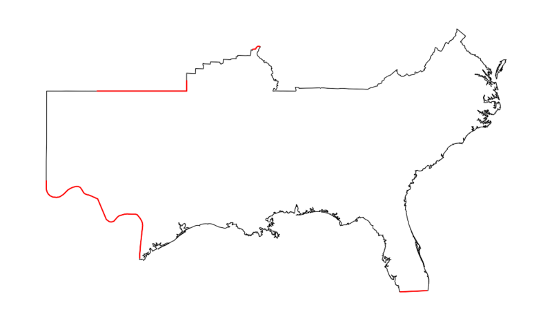
| Beschreibung | Confederation of American States |
Korrekturlinie 1: Grenze Aztlan--CAS
-103.064164 31.99964
-103.064164 31.956523
-103.064164 31.710713
-103.064164 31.599884
-103.049859 31.525923
-103.00667 31.414872
-102.949085 31.328406
-102.833913 31.229491
-102.675552 31.167614
-102.445209 31.142853
-102.243657 31.179993
-102.027711 31.303687
-101.883746 31.427218
-101.754178 31.538255
-101.610213 31.612205
-101.451851 31.673785
-101.279094 31.710713
-101.135129 31.710713
-101.019958 31.661473
-100.933579 31.562911
-100.832803 31.414872
-100.775217 31.353118
-100.674441 31.303687
-100.501684 31.266596
-100.386513 31.229491
-99.969015 31.068529
-99.450741 29.996801
-99.37876 29.946664
-99.277984 29.883957
-99.162813 29.858862
-99.004451 29.8965
-98.88928 30.009332
-98.788505 30.109517
-98.687729 30.184588
-98.342214 30.272099
-98.198249 30.284594
-97.953509 30.272099
-97.723165 30.272099
-97.593597 30.247104
-97.536011 30.184588
-97.42084 30.059436
-97.320064 29.909044
-97.276875 29.796099
-97.262478 29.670452
-97.392046 28.646905
-97.435235 28.175952
-97.435235 27.946078
Korrekturlinie 2: Grenze CAS--Karibische Liga
-81.75497 26.118226
-80.160039 26.184406
Korrekturlinie 3: Grenze CAS--UCAS
-100.004463 36.498
-94.61 36.498
-94.61 37
Korrekturlinie 4: Grenze CAS--UCAS
-90.65 38.505
-90.464474 38.517844
-90.415127 38.59534
-90.375033 38.626798
-90.322601 38.648569
-90.214655 38.641313
Dateiversionen
Klicke auf einen Zeitpunkt, um diese Version zu laden.
| Version vom | Vorschaubild | Maße | Benutzer | Kommentar | |
|---|---|---|---|---|---|
| aktuell | 23:44, 30. Jul. 2010 | | 1.000 × 574 (133 KB) | Loki (Diskussion | Beiträge) | {{Karteninfo |LIZENZ=[http://creativecommons.org/licenses/by-nc-sa/3.0/ Creative Commons Attribution-Noncommercial-Share Alike 3.0] |PROJEKTION=Mercator-Projektion, Standard-Longitude: 0° oestl. Laenge |QUELLE=Global Administrative Areas [http://www.g |
Du kannst diese Datei nicht überschreiben.
Dateiverwendung
Die folgende Seite verwendet diese Datei: