Shadowhelix:Karten/Dokumentation/Staaten/Confederation of American States: Unterschied zwischen den Versionen
Zur Navigation springen
Zur Suche springen
(+Aenderung auf css-Style) |
K (+IdxTab) |
||
| Zeile 3: | Zeile 3: | ||
[[Datei:Illustration Aufteilung von Virginia.png|thumb|200px|right|Aufteilung von Virginia]] | [[Datei:Illustration Aufteilung von Virginia.png|thumb|200px|right|Aufteilung von Virginia]] | ||
*Shadowrunspezifische Strukturen: 4 Korrekturlinien | *Shadowrunspezifische Strukturen: 4 Korrekturlinien | ||
*Referenz:{{ | *Referenz:{{Qen|sr4a}} S. 378 Karte Nordamerika, {{Qen|sona}} S. 169 Karte UCAS (insbesondere im Bezug auf die Zugehörigkeit der Delmarva-Halbinsel) | ||
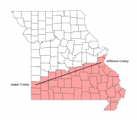
**{{ | **{{Qen|sona}} S. 71 "All counties intersecting or to the south of a line drawn from Jasper County to Jefferson County (just south of St. Louis) became the CAS state of South Missouri (with Springfield as state capital)." | ||
**{{ | **{{Qen|sona}} S. 177 "with the CAS border stretched to include a 'wedge' of old Missouri, with the point at St. Louis." | ||
**{{Quelle|nagna|S. 86 "Accordingly, part of Virginia remained UCAS territory, and was admitted to the UCAS as the state of North Virginia. This buffer zone is the portion of the state north of the Rappahannock River. Fredericksburg, straddling the Rappahannock on I-95, became the capital of Northern Virginia."}} | **{{Quelle|nagna|S. 86 "Accordingly, part of Virginia remained UCAS territory, and was admitted to the UCAS as the state of North Virginia. This buffer zone is the portion of the state north of the Rappahannock River. Fredericksburg, straddling the Rappahannock on I-95, became the capital of Northern Virginia."}} | ||
Version vom 12. Februar 2013, 20:50 Uhr
Confederation of American States
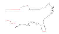
- Shadowrunspezifische Strukturen: 4 Korrekturlinien
- Referenz:Shadowrun 20th Anniversary S. 378 Karte Nordamerika, Shadows of North America S. 169 Karte UCAS (insbesondere im Bezug auf die Zugehörigkeit der Delmarva-Halbinsel)
- Shadows of North America S. 71 "All counties intersecting or to the south of a line drawn from Jasper County to Jefferson County (just south of St. Louis) became the CAS state of South Missouri (with Springfield as state capital)."
- Shadows of North America S. 177 "with the CAS border stretched to include a 'wedge' of old Missouri, with the point at St. Louis."
| Informationen |
20xx-2072
| Zusammensetzung | |||
|---|---|---|---|
| Struktur | Anmerkung | ||
| + | USA - Alabama | ||
| + | USA - Arkansas | ||
| + | USA - Florida | ||
| + | USA - Georgia | ||
| + | USA - Louisiana | ||
| + | USA - Mississippi | ||
| + | USA - North_Carolina | ||
| + | USA - South_Carolina | ||
| + | USA - Tennessee | ||
| + | USA - Texas | ||
| + | USA - Virginia | ||
| + | USA - Oklahoma | ||
| - | USA - Oklahoma - Beaver | ||
| - | USA - Oklahoma - Cimarron | ||
| - | USA - Oklahoma - Texas | ||
| + | USA - Missouri - Barry | ||
| + | USA - Missouri - Bollinger | ||
| + | USA - Missouri - Butler | ||
| + | USA - Missouri - Cape Girardeau | ||
| + | USA - Missouri - Carter | ||
| + | USA - Missouri - Christian | ||
| + | USA - Missouri - Crawford | ||
| + | USA - Missouri - Dade | ||
| + | USA - Missouri - Dallas | ||
| + | USA - Missouri - Dent | ||
| + | USA - Missouri - Douglas | ||
| + | USA - Missouri - Dunklin | ||
| + | USA - Missouri - Greene | ||
| + | USA - Missouri - Howell | ||
| + | USA - Missouri - Iron | ||
| + | USA - Missouri - Jasper | ||
| + | USA - Missouri - Jefferson | ||
| + | USA - Missouri - Laclede | ||
| + | USA - Missouri - Lawrence | ||
| + | USA - Missouri - Madison | ||
| + | USA - Missouri - McDonald | ||
| + | USA - Missouri - Mississippi | ||
| + | USA - Missouri - New Madrid | ||
| + | USA - Missouri - Newton | ||
| + | USA - Missouri - Oregon | ||
| + | USA - Missouri - Ozark | ||
| + | USA - Missouri - Pemiscot | ||
| + | USA - Missouri - Perry | ||
| + | USA - Missouri - Phelps | ||
| + | USA - Missouri - Polk | ||
| + | USA - Missouri - Pulaski | ||
| + | USA - Missouri - Reynolds | ||
| + | USA - Missouri - Ripley | ||
| + | USA - Missouri - Sainte Genevieve | ||
| + | USA - Missouri - Saint Francois | ||
| +* | USA - Missouri - Saint Louis | modifiziert mit -100.004463 36.498 / [..] / -94.61 37 | |
| + | USA - Missouri - Scott | ||
| + | USA - Missouri - Shannon | ||
| + | USA - Missouri - Stoddard | ||
| + | USA - Missouri - Stone | ||
| + | USA - Missouri - Taney | ||
| + | USA - Missouri - Texas | ||
| + | USA - Missouri - Washington | ||
| + | USA - Missouri - Wayne | ||
| + | USA - Missouri - Webster | ||
| + | USA - Missouri - Wright | ||
| - | USA - Virginia - Accomack | ||
| - | USA - Virginia - Alexandria | ||
| - | USA - Virginia - Arlington | ||
| - | USA - Virginia - Fairfax | ||
| - | USA - Virginia - Fauquier | ||
| - | USA - Virginia - Fredericksburg | ||
| - | USA - Virginia - King George | ||
| - | USA - Virginia - Lancaster | ||
| - | USA - Virginia - Loudoun | ||
| - | USA - Virginia - Northampton | ||
| - | USA - Virginia - Northumberland | ||
| - | USA - Virginia - Prince William | ||
| - | USA - Virginia - Richmond | ||
| - | USA - Virginia - Stafford | ||
| - | USA - Virginia - Westmoreland | ||
| * | -103.064164 31.99964 / [..] / -97.435235 27.946078 | Grenze Aztlan--CAS | |
| * | -81.75497 26.118226 / -80.160039 26.184406 | Grenze CAS--Karibische Liga | |
| * | -90.65 38.505 / [..] / -90.214655 38.641313 | Grenze CAS--UCAS | |


